Sunday, August 28, 2022

"Collisional models predict a lot more of these craters." -Patricio Salvador Zain


Did you know that the asteroid belt is one and a half AU (the distance between Earth and Sol) deep? And that all the big 4 asteroids including Ceres and Vesta have unique and distant orbits? There's a lot going on in the asteroid belt, but people overlook it. Not this speaker though, this LPI reveals the model all planetary scientists are now using.
  • The slide at 2:00 demonstrates that the belt is divided into six parts, six separate neighborhoods, that are all in resonance, meaning the individuals will rarely collide with anything big. At least not naturally.
  • At 6:10 we learn that Ceres is strangely depleted of large impact craters. That's what killed the old asteroid belt model. It's a direct discovery from the wildly successful DAWN mission.
  • At 13:40 you see that Ceres is mostly impacted by objects from the outer belt, and second from Ceres' own neighborhood, the middle-belt. While Vesta the dominant asteroid/dwarf planet in the inner belt, is least impacted by it's own neighborhood, although all six belts are about the same. This has to do with asteroids still working themselves into a sustainable resonance. The ones that haven't got there are the ones most likely to impact something, and they most likely will come from closest to Mars.
  • Conclusions at 16:20
Ceres and Vesta, along with Pallas and Hygiea, actually dominate their relative parts of the asteroid belt. It really is six different belts, not one. This is the tip of the iceberg though, studying the asteroid belt is a lot like studying the moons of Saturn and Jupiter. The more you look at it, the deeper it gets. 

This LPI was made because previous assumptions about the asteroid belt don't fit the observations. And you can tell from the speakers presentation, that the now updated model will still evolve with time and more observations. 


Saturday, August 27, 2022

Benjamin D. Boatwright & James W. Head


"Inverted fluvial channels"-Speaker

Great news. This one has timestamps embedded already. Better news, the slides are beautiful and packed with knowledge-bombs.

In the southern Noachian Highlands where the most ancient craters have not been wiped-out by erosion, they've still been eroded a bit. The rims are low and the basins are infilled. Some have a channel leading into them with an alluvial fan, some alluvial fans don't have a channel, but essentially most Noachian craters have an inlet of some kind, and quite a few have an outlet too. Classically people have assumed rain to be the erosive element, albeit very rare rain. But you don't need rain to explain things, and with each probe regular-rain becomes less and less a possibility. 

  • The slide at 5:55 has an example of lake features in a crater that has no obvious inlet. The implication is that groundwater seepage was involved since there is no inlet, but there are alluvial fans.
  • At 8:50 the speaker is still building up to the overall point, but that's because it is a HUGE point. Still I wanted to call attention to slide since it displays these inverted fluvial channels so well.
  • At 10:30 the speaker begins to make the argument that the crater features, were most likely formed in cold conditions. RSL's, recurring slope lineae, those are the "water-steaks" that have been noted forming and disappearing currently in the late Amazonian era. The suggestion is that the mechanics are the same.
  • At 13:45 the overall question is asked. 'are the features we see explicable by episodic melting events.' And where the climate models have always said that's what has to be, the geological evidence had been lacking, until this.
  • The whole lecture, including the Q&A is entertaining. Great questions come up.
These inverted fluvial channels are best explained as brine flowing under an icecap. Activity under the glaciers. That's why the cliff-facing-scarps have that backwards curve, and why the fluvial channels are inverted. You know how you see river beds on Mars and assume they are depressions instead of highlands because they look like dendritic rivers, but for some reason they usually aren't braided streams? That's because it's a cold fluid brine acting like a fluid brine, and not a river not acting like a river. 

Friday, August 26, 2022

"Some of the very largest secondaries, [typically those are usually about five percent of the diameter of the primary.]" -Kelsi Singer


This LPI is a study looking to infer what happened in the impact process. It's looking at secondary craters, craters made from the largest debris from the initial impact. So the size of debris should tell you something. What exactly?

  • The slide at 3:20 really gives you a feel for how many craters can be secondary impacts, not direct foreign impacts. This can be really eye-opening. The smaller debris are more likely to make escape velocity than the larger ones.
  • At 4:20, a high resolution close-up of diminutive secondary craters.
  • Slide at 4:32 shows you the V-shaped features, implying debris was skipping! Or at least entering at a very low angle.
  • Faint V-shaped secondary close-up at 5:00.
The remainder of the lecture is a whole lot of isolating simple variables to make estimation of ejecta more formulaic. This isn't difficult algebra, but it makes it plausible to do stuff like find an asteroid with a certain mass and velocity, and maybe scale back the path it took eons ago, to its initial crater. Albeit that wont apply to most asteroids, but that's sort of the upper-limit of what this kind of research can do.  

Thursday, August 25, 2022

 -Ashley M. Palumbo


"Abundant erosion that cannot be fully attributed to background erosive activity."

This LPI is a bit of an oddity in that the speaker isn't the speaker, they are the slideshow producer.

It's a simple concept. A massive impact has massive effects, right? Well on Mars, we expect that to be doubly true, since even small impacts seem to have had profound effects. 

Argyre Basin is the third largest Noachian impact basin after Helles Basin and Isidis Basin. They both represent the end of the Late Heavy Bombardment and the middle of the Noachian era. That basically means that the dynamo is long gone, the majority of peak-atmosphere is long gone, the big shield-volcanoes are just getting started, and Valles Marineris is an era and a half away from starting. Most likely topical-Mars is very frozen and still, just with a lot more ice than Amazonian Mars.

  • Pay attention to the slide at 3:40 and how not-still such an impact potentially can make Mars for a few centuries.
  • At 8:00 there is a nice slide comparing a similar crater on Luna, which has essentially no weather, and Argyre which experienced weak weather. Part of the argument in this lecture is that the weather caused by the Argyre impact is what eroded the older craters. 
  • At 12:10 the speaker mentions something exciting that Percy can do to test these premises. It will be a few years, but Percy has the chance to sample Noachian Mars, no lander has to date.
Among the great and persistent misconceptions that are ubiquitous in the click-bait media is the premise that Mars has an Earth-like lithosphere. It doesn't. Mars surface as anyone who has seen Percy or Curiosity drill into, is very fragile and porous. Yet the weather is weak, so much so that the soft ground once altered, stays altered. Over the eons, any great event, stays in the record.

This is why all major Mars formations, including riverbeds, eskers, and glaciation, are best explained as episodic. This LPI lecture, performed at the same conference as this one, may help some understand better. 

Wednesday, August 24, 2022

"I haven't really answered any questions yet." -Michelle Kirchoff


This is a really fun LPI. It involves comparing images of craters with focus on Mars' presumed wet splat-type rampart-craters.

Here's the thing, the law of superposition works well with crater ejecta. However you can't really interpret more than a few layers of overlapping ejecta. It works best on places like Callisto and Ganymede but also applies to Luna, Mercury, and Mars.

Mars in particular gets weird because it has a lot of Rampart-craters. You can employ the law of superposition in the Noachian south, but not so much around the Hesperian equator. So how do you infer some relative dating?

  • Slide at 2:60 shows a random distribution for both Ballistic-craters and Rampart-craters on Mars.
  • From 10:00 on she's showing older images compared with newer images of the same craters to demonstrate how the interpretation of ejecta type has changed. 
One would think you could just say that Rampart-craters are older than Ballistic-craters, but that doesn't seem to work. Frequently craters have traits of both types. It's entirely possible that all Rampart-craters were hybridized at first. Wind erosion seems to have dulled or removed a lot of radial ejecta.

In the end this LPI is the type that brings into question things one would have thought fairly straight forward. Which is neat. Now one can say that currently, in the case of Mars, dating craters is a bit more complicated. And this further throws into question the chemistry/mechanical-action that causes Rampart-crater morphology.     

Monday, August 22, 2022

"People assume a bar, I think, largely because that's what we have on the Earth" - James W. Head


So there's a huge detach between the idea of blue-Mars and real-Mars. You see, the south hemisphere exists. 

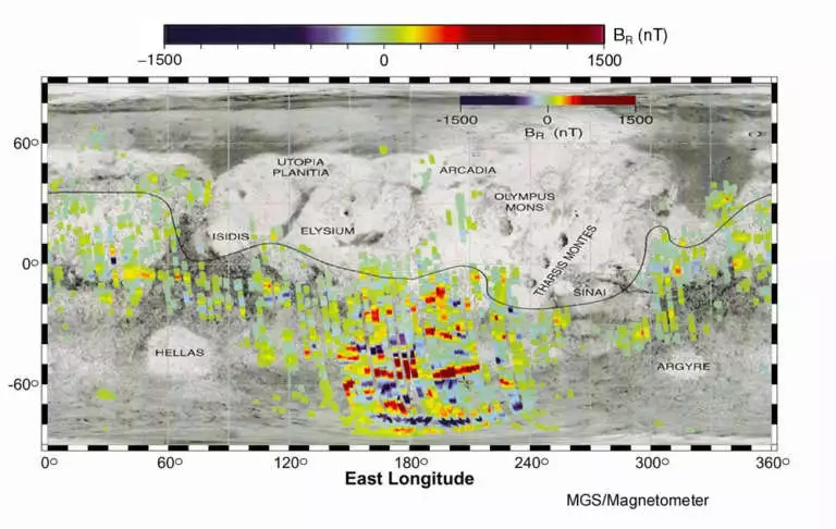
The southern Noachian highlands are dated by crater counting to make the surface at least 4.1 - 3.7 billion years old. There are magnetic bits in the Noachian south, but they are not heterogeneous. They are not oriented in a particular direction, implying that the lithosphere was still somewhat plastic when they were made, and they seem to have been destroyed by giant impactors, and are not present in or around the largest southern craters. Taken together this implies that when Mars had a magnetosphere, was also when the crust was still semi-molten, at least 4.1 billion years ago. 

This LPI is searching for answers. Mostly, it's identifying the questions. What does this mean about Mars atmosphere at that time and later? After-all, the craters have not been eroded... much. 

  • I like the slide at 7:30 just for giving us a nice guideline. Multi-ringed craters are probably older.
  • At 13:00 a slide showing sort of the old model, or the model that is under interrogation in planetary science. 
  • The slide at 13:50 I just want to mention for my own reference. That beautiful map showing the headwaters for Jezero crater is one I think I may refer to in the future.
  • Slide at 15:50 is where the problems kick in. If Mars had precipitation at all, it wasn't much, but the Noachian highlands still need an explanation for how much water they did cycle. This continues to be an unresolved and hotly debated topic. 
  • So now you see the debate. The slide at 16:20 and the slide at 15:00, are showing incompatible modeling. The data supporting one model conflicts with the other, and they must be resolved to find real-Mars. 
  • Slide at 17:30 details the ongoing questions to answer. Q2 will be very hard to answer, questions 3 & 6 seem more likely to get answers in the next few years. 
So this lecture wraps up a topic that I promise you, planetary scientists are almost willing to kill each other over right now. There's a lot at stake. Blue-Mars has no harborage in the Hesperian anymore, and may not have room in the Noachian either.


Sunday, August 21, 2022

"They didn't look like any concretions I'd ever seen" -Donald M. Burt


Alright, so this LPI is literally elementary for understanding Real-Mars. Almost everything in it is fundamental yet no one outside the planetary science field will know any of it unless they really try, and actually watch this LPI. Almost every spoken word in this LPI is golden. 

  • The facts come hard and fast in this LPI. Slide at 0:30.
  • Slide at 2:57. Dust can explain most Mars deposition. It wasn't water, it was dust that put the most common layers down.
  • Pay attention to what he says at the slide at 5:40
  • Super important. The slide at 7:11. Listen to what is said, and then note the importance of the new rover Perseverance which had not yet landed when this LPI first was uploaded. The Kodiak mesa has cross-bedding inside it. It's a huge deal, and planetary scientists are keeping it on the DL for now.
  • At 10:00. The theory about blueberries is now changed forever.
  • At 10:30. The Cross-bedding dilemma is explained perfectly.
  • Slide at 13:40. The plains around alluvial fans have more material in them than the canyon cut volume can fill. But the canyons funnel impact flows, making up the lions share of the deposition.
  • Slide at 15:30, simply drills home the Blueberry dilemma.
  • Watch the questions too after 18:30.
You rarely get knowledge-bombs dropped with this kind of frequency. LPI's and scientific papers are usually focused on one detail. This LPI represents one of those moments in history where a common belief is blown away by pure logos. 

I'll tell you the endgame of this. What all the Mars science is heading to is that Mars has always been an ice-ball losing it's ice. Glacial action dominated the north through the Hesperian, but only episodic action, eruptions and impacts, cut the river beds and gullies. It possibly never rained outside impacts. Mars lost it's magnetosphere and the lions share of it's atmosphere at the same time in the Prenoachian,when the crust was still mostly soft. There never was a "blue-Mars."

  Frankly, I could use some book-reports. So I write this as a solicitation page to refer to. The following is a teaser for the book. ABSOLU...